Maps
This sample of maps were created using the ArcMap Software, employing opendata information available at the Esri database. The prefered projection used was the WGS 1984. The methodology for the development of the maps was based on the use of historical primary sources such as ship logs, travel accounts, old projections and biographical information. The maps are co-authored by cartography and Geomatics specialist Mariana Tiné, MSc.

Project Coordinator. Website “Equiano's World - Gustavus Vassa and the Abolition of the British Slave Trade” . SSHRC (Since 2016)
Equiano traveled extensively, having come from the interior of the Bight of Biafra, in the heart of Igboland, and taken to the coast, probably leaving via the slave port of Bonny in 1754. By his own account, he was taken to Barbados and then to Virginia, where he was bought by British naval officer, Captain Michael Henry Pascal (d. 1786) from a tobacco planter by the name of Campbell and taken to England. His subsequent travels are identified in the Equiano’s website portal. The maps in the Equiano’s World Project have clean presentation and are intended to be resources to be used by school teachers and the general public.
Director.” Projeto Baquaqua”. Multimedia Digital Humanities Project and Public History Engagement. Ministry of Culture, Brazil (Since 2013)
Section with maps representing different events on Baquaqua biography for being used for teachers in elementary and high school with accessible understanding to the general public.
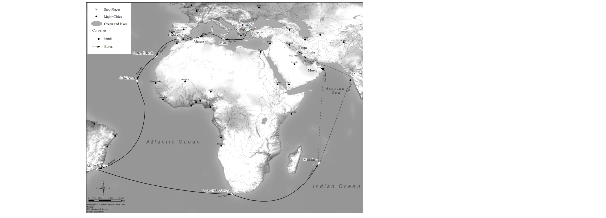
Ottoman Steam Corvettes Izmir and Bursa, 1865-1866 (PhD Dissertation)
Map representing the travel of the two Ottoman Steam Corvettes Izmir and Bursa (1865-1866) from Istanbul, stopping in Rio de Janeiro, and finally arriving in Basra. The production of this map involved research in several travel accounts, ship logs and Newspapers from England, France, Brazil and Turkey.